
AI4SoilHealth aims to accelerate soil health monitoring across Europe with Artificial Intelligence
Healthy soils provide the foundation for climate resilience, food production, clean water, and biodiversity. When functioning well, soils capture carbon, regulate floods, support crop yields, and sustain complex biological communities. Yet across Europe, these essential functions are under threat. Current agricultural pressures, rising food demand, and the accelerating effects of climate change are driving widespread soil degradation. Loss of organic matter, declining biodiversity, compaction from heavy machinery, contamination, and erosion are now common across many landscapes. It is estimated that 60–70% of EU soils are unhealthy, posing significant risks to food security and ecosystem stability.
Reversing this trend requires a clear understanding of how soils change, which management practices support recovery, and where interventions are most urgently needed. Because soils are highly variable in space and time, a modern soil monitoring system must continuously track conditions. It must also detect change early, and help decision-makers plan effectively for the specific characteristics of each locality.
Aligning purpose with action
AI4SoilHealth is a major Horizon Europe initiative aimed at developing the next generation of soil-monitoring tools for Europe. Coordinated by Aarhus University, the project brings together 28 expert partners from research institutes, universities, SMEs, NGOs, and industry across 11 countries, representing a wide range of soil, climate, and land-use conditions. Over four years, the consortium seeks to co-design and implement a unified digital infrastructure, a European-wide Soil Digital Twin capable of assessing, tracking, and forecasting soil health.
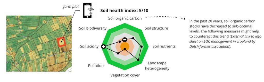
At the heart of the project is a commitment to open access. AI4SoilHealth is currently developing a free, user-friendly app combining artificial intelligence, Earth Observation data, advanced soil measurement techniques, and field reporting tools. The application will help farmers, growers, advisors, and policymakers evaluate soil condition and adapt their management practices with confidence. Co-design teams will work with farms, living labs, and pilot sites across Europe to collect data, build models. This will ensure that the system reflects real conditions on the ground.
As Ichsani Wheeler of the OpenGeoHub Foundation explains:
«Only farmers and land managers are the agents of change in a landscape. As an open-source community of researchers, we hope that by surfacing existing and cutting-edge soil information through space and time, we can cultivate an environment of self-determination for farmers, to the benefit of all our children».
Objectives and methodology
AI4SoilHealth is designed around seven interconnected objectives that together form a comprehensive soil health monitoring system for Europe. The project also contributes directly to the broader EU Soil Mission, which aims to improve soil health by 2030. This mission includes eight overarching objectives. They range from reducing desertification and preventing erosion to enhancing biodiversity and reducing Europe’s global soil footprint. This includes the development of 100 Living Labs and Lighthouses where practical soil restoration techniques are tested. AI4SoilHealth collaborates closely with other Soil Mission projects, including EJP Soil, Soil Health Benchmarks, PrepSoil, WorldSoils, and Soil-o-live. This collaboration ensures that high-quality measurement tools support regenerative practices across Europe.
Co-designing indicators and next-generation measurements
The first objective is to co-design a Soil Health Indicator framework with stakeholders, including EU agencies, national authorities, farmers, and advisors. These discussions help define the information required for planning, regulation, and management. Their insights then shape the development of a practical Soil Health Index that stays true to the mission’s objectives.
The second objective focuses on next-generation indicators and measurements. The approach brings together traditional soil sampling and cutting-edge technologies. Among them are visible–infrared spectroscopy, environmental DNA (eDNA), soil enzymatic activity sensors, and other tools capable of high-frequency, in-situ monitoring. These methods help identify realistic and cost-effective proxy indicators for soil functions such as carbon storage, nutrient cycling, biodiversity, and infiltration.
A third objective is to develop a Soil Health Assessment Toolbox that translates measurements into usable information. This toolbox will provide intuitive indicators (such as traffic-light assessments) alongside deeper analytical layers for advanced users.
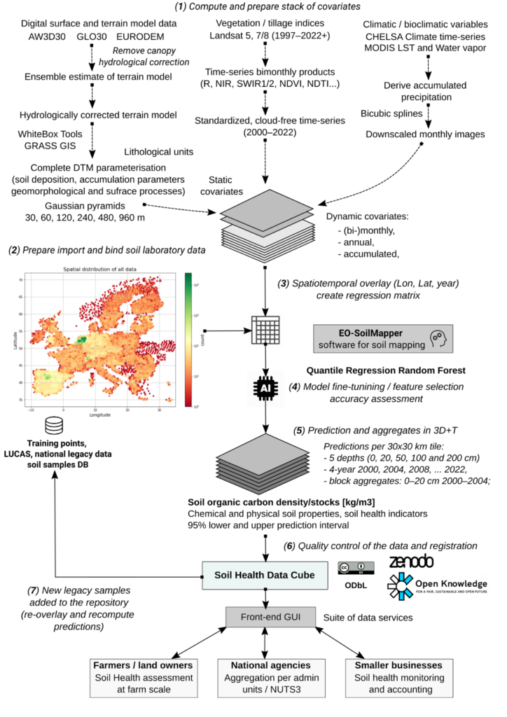
Central to the project is the creation of the Soil Health Data Cube. It is a harmonized, cloud-optimized infrastructure that integrates soil observations, process-based models, and the latest Earth Observation data. Machine learning, deep learning, and hybrid (AI + mechanistic) models will be employed to map key soil properties down to 2 meters and detect trends from annual or sub-annual time series. These data streams will feed into a European Soil Health and Soil Degradation Monitor. It is a tool designed to track erosion, SOC loss, salinity, vegetation decline, and other pressures.
Pilot sites, validation and capacity building
To ensure robustness and relevance, AI4SoilHealth collaborates with 20 pilot sites representing 11 of Europe’s 13 pedo-climatic regions. These sites include diverse environments from Danish peatlands and Mediterranean valleys to Swedish long-term agricultural trials and the TERENO environmental observatories in Germany. Living Labs and local soil managers participate directly, helping validate indicators, refine tools, and evaluate forecasts under real-world conditions.
Finally, the project places strong emphasis on capacity building and soil literacy, producing training materials, video tutorials, and a progressive web app to support user engagement and knowledge exchange.

Towards the first operational soil health maps
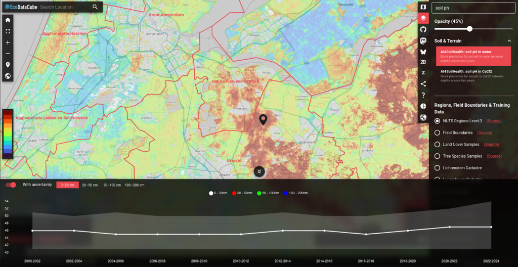
Although still in its early phases, AI4SoilHealth has already made progress on several key elements. Stakeholder consultations have clarified policy needs and supported the draft architecture of the Soil Health Index. Teams have begun harmonizing LUCAS and national soil datasets, preparing them for integration into the Data Cube. Currently, the soil health data cube can be seen in ecodatacube.eu, the frontend GUI platform that was created to showcase the dataset. This frontend GUI is able to showcase each of the soil health data cube layers. The feature includes a query point to check the zone statistics of the selected area over the years utilizing the temporal dimensions of the data cube. An example can be seen in Figure 4. It shows a block of predictions of soil pH in water and their trend including the uncertainties in different depth levels. Prototype Digital Twin components such as EO-derived vegetation indicators, land cover layers, and preliminary soil trend analyses, are under review. Several pilot sites have launched sampling activities to test spectral measurements, biological indicators, and in-situ sensors. These initial steps provide the foundation for scaling up indicator testing and generating the first operational soil health maps.
Upcoming releases
Some of the yet-to-come outputs of the project include a fully validated Soil Health Index, a suite of proxy indicators, and a high-resolution Soil Digital Twin capable of annual updates. Land managers will gain access to Soil Health Cards and benchmarking tools. Meanwhile researchers and policymakers can explore detailed Soil Health and Degradation maps through the Data Cube and its API.
By bringing together advanced measurement tools, AI models, Earth Observation, and the voices of soil practitioners, AI4SoilHealth is laying the groundwork for a system that can evolve with future needs. This joined-up effort supports more informed choices today and helps set the path toward healthier soils and healthier communities, well into the future.
References:
- Tian, X., Consoli, D., Witjes, M., Schneider, F., Parente, L., Şahin, M., Ho, Y.-F., Minařík, R., and Hengl, T.: Time series of Landsat-based bimonthly and annual spectral indices for continental Europe for 2000–2022, Earth Syst. Sci. Data, 17, 741–772
- Tian X, de Bruin S, Simoes R, Isik MS, Minarik R, Ho Y, Şahin M, Herold M, Consoli D, Hengl T. (2025). Spatiotemporal prediction of soil organic carbon density in Europe (2000–2022) using earth observation and machine learning. PeerJ13:e19605
- Witjes, M., Parente, L., Križan, J., Hengl, T., & Antonić, L. (2023). Ecodatacube. eu: analysis-ready open environmental data cube for Europe. PeerJ, 11, e15478
- ecodatacube.eu