
The BRIGANTINE project and the TRIDENT system embody coastal monitoring 4.0 for the Northern Adriatic Sea
Shallow coastal areas, lagoons, and estuarine systems are among the most biodiverse and fragile environments on the planet. In these contexts, seabeds colonised by seagrass play a key role in maintaining ecosystem balance. They regulate nutrient cycles, provide habitats and nursery areas for aquatic species, and contribute to coastal protection against erosion. They also act as natural carbon sinks, known as Blue Carbon. At the same time, these ecosystems are highly vulnerable to anthropogenic pressures and environmental change, which affect their vitality, spatial distribution, and biodiversity.
Within this framework, BRIGANTINE is a competitive standard project funded by the Interreg Italy–Croatia VI CBC Programme 2021–2027. It is aimed at developing innovative tools for high-resolution monitoring of coastal environments in the Northern Adriatic Sea.
The project led to the development of TRIDENT (Telemetry & Reconnaissance for Integrated Data-gathering in ENvironmental Tracking), an autonomous robotic platform designed to operate in lagoon environments and shallow sandy waters. In these contexts, traditional monitoring approaches face significant constraints. Crewed vessels are often difficult and costly to deploy, while in-water human presence can disturb environmental conditions, particularly in highly turbid areas. Satellite remote sensing, although essential, does not provide sufficient spatial resolution for detailed local analyses.
A modular ASV integrating multi-sensor data
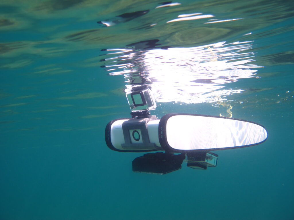
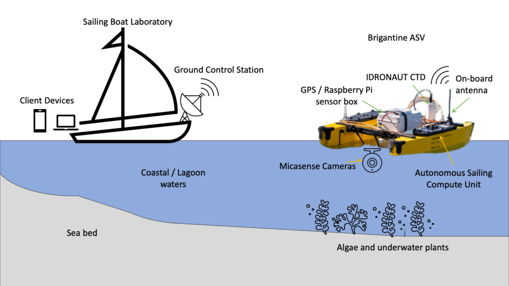
The technological core of the project is the Brigantine-ASV, a modular and cost-effective Autonomous Surface Vehicle conceived to bridge the gap between satellite observations and in situ measurements. The prototype was developed using an open and flexible architecture. This allows the integration of multiple sensors and adaptation to different operational scenarios. Navigation and control rely on open-source solutions, including ArduPilot firmware and an industrial-grade flight controller (Orange Cube+), integrated with a high-precision GNSS receiver capable of centimetre-level positioning accuracy. The platform is equipped with onboard sensors, including an Idronaut Ocean Seven 304 CTD probe for measuring key physico-chemical water parameters, such as conductivity, temperature, and depth. It also includes a single-beam echosounder (Ectos) for shallow-water bathymetric surveys. Advanced remote sensing capabilities are provided by RGB cameras and multispectral sensors (Micasense Altum-PT). These are used to analyse the distribution and health status of submerged vegetation, particularly seagrass meadows.
The IoT infrastructure represents another key system component. An onboard computer (Raspberry Pi 4) manages data acquisition and real-time telemetry transmission to the Ground Control Station via the MAVLink protocol and the Herelink communication system, enabling continuous mission monitoring and immediate access to collected data. The sensor package is fully customisable, with a focus on smart sensor integration.
Monitoring methodology and expected results
ASV Brigantine, thanks to its TRIDENT format, performs fully autonomous missions, following predefined trajectories and sampling grids based on waypoints. During navigation, this marine drone simultaneously acquires physico-chemical water data, bathymetric information, and multispectral bands that are merged to generate images of submerged vegetation. Data integration enables the generation of high-resolution maps, to assess the health of coastal ecosystems – such as sediments and algae – and their capacity for carbon sequestration.
The main objective of BRIGANTINE is to deliver an accessible and replicable research platform capable of generating reliable, high-precision GNSS-based georeferenced datasets on water quality and submerged vegetation status. Field tests show that the TRIDENT system is particularly effective in critical shallow-water environments inaccessible to conventional vessels. It provides higher spatial resolution for underwater measurements than aerial drones (UAVs) when assessing submerged components. The platform also offers strong modularity for future integration of advanced electrochemical sensors.
Expected outputs include high-resolution georeferenced databases containing physico-chemical water parameters – such as temperature, conductivity, and pH – with multispectral imaging data for submerged flora classification and monitoring. The project also includes the development and validation of autonomous navigation protocols in shallow waters. These are implemented on the modular TRIDENT ASV and supported by a real-time telemetry dashboard based on the MAVLink protocol.
The data-fusion of chemical information and multispectral images is the high value offered by this technology: data processing enables the definition of advanced scientific indicators, including Seagrass Health Indices derived from multispectral imagery analysis (collected by Micasense Altum-PT), supporting quantitative assessments of seagrass meadow health.
Benefits for coastal management
The project has strategic relevance for integrated coastal zone governance and evidence-based management. The BRIGANTINE–TRIDENT system supports quantitative and continuous monitoring of key environmental parameters. This contributes to the assessment of ecosystem functioning and carbon dynamics in support of climate-change mitigation strategies. The availability of consistent, high-resolution georeferenced datasets supports adaptive management of aquaculture and tourism activities, ensuring compliance with environmental quality standards while reducing ecosystem risks.
At the same time, the integration of data into visualisation dashboards and Decision Support Systems (DSS) provides policy-makers with effective operational tools for emergency management and planning. Finally, the production of high-resolution risk and vulnerability maps strengthens spatial planning and conservation processes. This facilitates targeted measures to enhance ecosystem resilience to extreme climate events in line with national and European regulatory frameworks.
References:
- Gemolotto L., et al. Telemetry & Reconnaissance for Integrated Data-gathering in ENvironmental Tracking (TRIDENT) for Shallow Sea Monitoring with Autonomous Surface Vehicles (ASVs). Remote Sensing. 2025
- D.Tavaris, L.Scandino, G.Foresti, I.Scagnetto. A cost-effective autonomous underwater system for small size object detection. Integrated Computer-Aided Engineering. 2025
- A.Odetti, G.Bruzzone, R.Ferretti, S.Aracri, F.Carotenuto, C.Vagnoli, A.Zaldei, and I.Scagnetto. Lake Environmental Data Harvester (LED) for Alpine Lake Monitoring with Autonomous Surface Vehicles (ASVs). Remote Sensing. 2024
- Su, J., et al.Spectral analysis and mapping of blackgrass weed by leveraging machine learning and UAV multispectral imagery. Computers and Electronics in Agriculture. 2022
- ArduPilot Project. Open Source Autopilot Systems for Autonomous Vehicles. 2025


